

A sweeping view of the Smokies from Mount LeConte.
There are some things that don’t agree with me. Black Friday is one of them.
The idea of it—getting up ridiculously early, fighting crowds, spending wads of money and feeding the increasingly ravenous commercialism that has become Christmas is a major turnoff for me. I’ve spent the last three Black Fridays getting up early, lining up at the start line and running a 5K. Way more fun than storming the ramparts of Wal-Mart of Best Buy.
This year was going to be different, as a family get-together in Tennessee for Thanksgiving was on deck, so no race this time. I’ve never been to Tennessee before, but I’ve heard some good things about the natural beauty of the Volunteer State, particularly at its eastern edge.
I floated a plan to spend Black Friday in the Smoky Mountains, and to join like-minded people who were joining in REI’s #OptOutside movement is getting outdoors instead of stampeding the malls.
Some context…
It’s been a funny year for me. I got lazy, a little chunky, and paid for it. Dreams of summits and big races got whittled down to meager results: a failed bid at Longs Peak, a half-hearted spring trail race, and hitting just one summit – a minor 13,000-foot peak in Colorado – were all I had to show for my labors. I rallied in the fall by doing a few road races (my season-long decision choosing not to suck), but I still felt the need to try to bag one more peak before the year ended. So why not one of the Smokies’ biggies in Tennessee? It seemed a shame to get that close to a mountain range I’d never seen and not try to get out there. One peak in particular caught my eye: Mount LeConte.
Why Mount LeConte?
When I started wrapping my mind around this idea, I immediately gravitated toward trying to find the state’s highest point. That mountain would be Clingman’s Dome at 6,643 feet. That sounded cool and all, seeing I’ve got a few other state high points under my belt. But after researching the mountain, one thing stuck out – there’s a huge concrete observation tower at the summit, which is not something I want to see when I’m out in the woods going up a mountain.
I took to social media and asked around, and more than once, Mount LeConte came up as the place to go when it comes to a summit hike in the Smokies. In particular, the Alum Cave Trail was noted as being the most scenic of the many routes to LeConte’s 6,593-foot summit.
One couple’s opinion rang particularly true – Dan and Ashley Walsh, who live in Georgia and frequent the Smokies quite often. I’ve seen their Instagram pages, and their many photos of LeConte. When in doubt, trust those who have been there before.

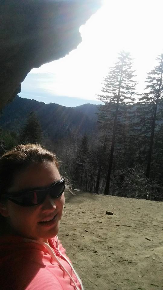
Jen and I at the trailhead, getting ready for the big day.
A partner in crime…
I don’t mind doing stuff like this solo. The solitude of hitting the trails on your own has its own special aesthetic appeal, but truth be told, I prefer going with people.
I also know that a big day of hiking is not for everyone. So I brought up the idea of bringing people along, if they so chose. I got one taker.
My sister-in-law Jen digs the outdoors. She loves travel. But she’s also a mom of two boys, a wife and a one-woman landscaping show, operating her own business in a few towns north of Tulsa. It’s not like the gal has a bunch of free time on her hands, so when offered the chance to do something different – even if it meant many hours of driving and a big day on the mountain – she was game.
Never mind that she hadn’t done a hike this long or this high in her life. A willing soul is all it takes. We’ll sort out the blisters and aches/pains later.
So what about that mountain…
As I said before, Mount LeConte is one of the behemoths of Great Smoky Mountains National Park, the third highest in the park and one of the biggest in all of the southern Appalachians. The range itself, stretching about 1,500 miles from northern Alabama into Newfoundland in Canada, is one of the world’s oldest, forming some 480 million years ago. Geologists say that at their peak, the Appalachians may have been as high or higher than the Himalayas.
But all those eons of rain, snow, wind and gravity have eroded them to what they are today, their slopes more gentle and their flanks clothed in forest (though up north, there are treelines on the higher mountains). LeConte stands nearly as tall as any of the peaks in the range, and indeed, despite its age, it’s still a sizable peak. LeConte’s base is low, maybe a bit more than 1,000 feet above sea level, meaning the mountain itself rises more than a mile. A good number of famous Rocky Mountain peaks don’t have that sort of rise.
Its height is also reflected in its size. LeConte dominates the eastern skyline in the tourist towns of Sevierville, Pigeon Forge and Gatlinburg. No route to the top is less than 11 miles round trip.
That 11-miler is also the steepest, and just so happens to be the route we picked – the Alum Cave Trail.

Alum Cave Creek, low on the trail.
The hike…
It should be noted that Great Smoky Mountains National Park is the nation’s most popular, getting more visitors than even Yosemite or Yellowstone. Being so close to those tourist towns and on a day where a lot of people were off work, I knew it was going to be a busy day on the trails. I was right on that count. I’m not sure the two of us went 10 minutes without seeing other people.
This was especially true lower on the mountain. Most people who hike the trail go up to Alum Cave Bluff, then turn around there.
It starts flat, winding through a mix of broadleaf and evergreen woods while following Alum Cave Creek. It’s a pretty stretch, still very green despite being in late autumn. Moss covered rocks and tree trunks all around. Unlike the mountains I’m used to hiking, this range is quite humid and gets plenty of rain. I imagine summer hiking around here gets pretty sticky.
The trail steepened as we approached a feature called Arch Rock, which has a cleverly placed stone staircase that goes through the arch and begins the first steep pitch of the hike.

Looking back at the stairs at Arch Rock. (Jen Baines photo)
Given the trailhead sits just short of 4,000 feet above sea level, I think most people might underestimate the difficulty of the hike – right up until they begin that stair climb through Arch Rock. Four-thousand feet will feel fine to any flatlander who is standing or sitting still, but add a good uphill pitch and it becomes noticeable. If you’re not used to higher elevations, keep in mind that when you hike here, thinner air will make the going a bit tougher. It won’t make you sick (a common problem in the Rockies and other higher ranges), but it will add to the effort you expend.
Past Arch Rock, the grade maintained a steeper pitch than what we saw in the first couple of miles, gaining a higher angle as we approached the trail’s namesake, Alum Cave Bluff.
Jen takes in the view from Alum Cave Bluff. (Jen Baines photo)
First off, Alum Cave is not really a cave. Instead, it’s a prominent chunk of overhanging rock that builds a sort of shelter at the base. It’s dramatic, and the views from the bluff are worth the effort to get there. I can see why this hike is so popular, with the sweeping scenery and accessibility from the trailhead. I can also see why a lot of day hikers choose to turn around here instead of continuing to the summit. A sign tells you that the summit is still 2.7 miles away, and there is a lot of elevation gain between the bluff and the top.
We decided to take a breather here. One of the things I wanted to do was make sure that our pace was even and sustainable. No sense blowing ourselves out getting to the summit. I broke up the ascent into one-hour segments where we’d take a break, eat a little something, drink and maybe stretch out. So part of my job was to be a good timekeeper, letting Jen know, “Hey, let’s go another 15 minutes and then take a break,” and keep it steady. Jen was a little beat when we got to Alum Cave, but the one thing I’ve discovered about her is she has a second gear when it comes to toughness. Outside observers might have thought she was ready to cash it in, but more than once, she told me that there was no way she was going to stop before we topped out. Her spirit was willing, the weather was good, and a lot of great hiking awaited.

As we went higher, the views opened up.
As is often the case on trips like this, we talked a lot. She asked me if I thought her boys would be able to do a hike like this. I said yes, but it would be a case of if they wanted it badly enough. Hard work and short attention spans can cut off willpower when it comes to the younger set, but there are plenty of little rippers out there who can and do hike and climb some pretty big peaks.
We also noticed accents and nationalities. Jen heard lots of voices that sounded like they heralded from the Middle East, India and the Far East.
I noticed those too, but more than that, I was taken aback by the variety of Southern accents. Some sounded Deep South, others more Cajun. I can definitely tell the difference between the sugary-sweet Tennessee or Georgia southern accents from what I normally encounter in Oklahoma and Texas. Call me weird, but I thought it was fascinating. Maybe that’s why my Colorado friends keep inviting me on their trips – to hear that funny Okie accent I picked up as a teenager.

Steeper hiking and changing flora on the upper slopes.
The higher we went, the more things changed. There is no treeline on LeConte or any of the other Smokies, but the rapidly changing elevations meant there would be subtle differences in what you saw around you. What was just wet lower down turned into thick patches of ice higher up. The more lush broadleaf plants and trees below were supplanted by thickening groves of spruces and firs, and as the summit neared, the forest gained that familiar scent of the evergreen woods from Rocky Mountain hikes past, sort of like the sweet, fresh smell of a live Christmas tree in your house right after it’s been cut. That never gets old, and it was nice to smell it again on LeConte’s upper slopes.

Views for days.
Nearing the top, the trail leveled out and before we knew it a confluence of other trails split off into different directions, pointing toward other routes down and to the Cliff Tops overlook nearby. And in front of us, a collection of rustic cabins, collectively known as the LeConte Lodge. It was closed this time of year, but you can reserve a cabin when it’s open. The catch – very few utilities, and you have to hike to get there. I like the concept – you earn your stay with a little sweat equity on the trail.

Me at the summit, with the cairn behind me. And lots of trees.
LeConte’s summit was still a half-mile away, so we kept trucking. Jen was thinking we might have reached it already, but I kept telling her you’ll know you’re there when there’s nowhere else you can go to get higher. Before long, we were there, greeted not by some sweeping summit view, but a giant cairn tucked away in the trees. I’m used to cairns, but it was a little strange to top out and see nothing but woods around me. Fortunately, there were breaks in the trees down the trail that featured expansive overviews of the Smokies all around. For as far as I could see, miles and miles of long, high wooded ridges below us, giving us some of the choicest panoramas in all of the South.

A view a little down from the summit.
With the summit it in the bag, we headed back down to the lodge, found a picnic table and chowed down. A married couple was wandering around, looking for water, so Jen obliged and gave them some of hers. It’s hard to believe anyone would do a hike as long as this one without more than a single 16-ounce bottle on hand, but I suppose it happens. With mild temps that day, I suppose you could get away with it, but seriously, take more than you need. You never know what might happen, and the sun sets early out there in late fall. Anyway, the dude returned the favor by handing us a Butterfinger bar, which I happily accepted. No sense turning down free food, right?

Jen at the LeConte Lodge, posing for a potential gig as a brand ambassador for Capri Sun. (Jen Baines photo)
Eventually it was time head back down. Our late start (traffic through Sevierville/Pigeon Forge/Gatlinburg is a bit slow) meant getting down before dark would be a push. After a bit, Jen said, “Going back down feels kinda sad.”
“Why is that?” I asked, my mind drifting toward what might be up for dinner once we got down.
“Because it’s almost over,” she answered.
I reassured her that there were plenty of good times in front of us on the way back to the trailhead. After all, the trail always looks different going the other way, and with the sun heading down the fading brightness of daylight bathed the hills and the woods with a warm glow that belied the growing chill in the air. Sensory overload, to be sure, and I mean that in the best way.

Heading back down. Many parts of the trail hug cliffsides, which offer dramatic views of the mountains.

Late afternoon light, and plenty to see to fire the imagination.
But what she said resonated with me. I understand exactly what she meant, that heading back to the trailhead was a step closer to leaving the adventure behind and going back to “real life” and all of its obligations, stresses and tedium. Also, the fact that the end of the trip brought about a little sadness meant that the hard work, the sweat, the soreness – all that “second-level fun” most people don’t enjoy, but a few of us relish – was worth something to her. I suspect she expected that before the hike started, but having that confirmed when it was ending was particularly gratifying. I go out there because I enjoy it, but there is a special satisfaction in taking someone on a big hike like this and turning them on to the things that the outdoors has to offer. Adventure ain’t for everyone because it’s hard. But for those who get a taste and then a fire lights in their eyes, well, getting the adventure bug can be a little like magic. Life-changing, wonderful magic.

Trail magic.
So another Black Friday has come and gone, without me spending a single second shopping for anything. By opting outside, I’m sure Jen would agree with me on this: Better and more lasting memories were made on that trail then could ever have been made in line.
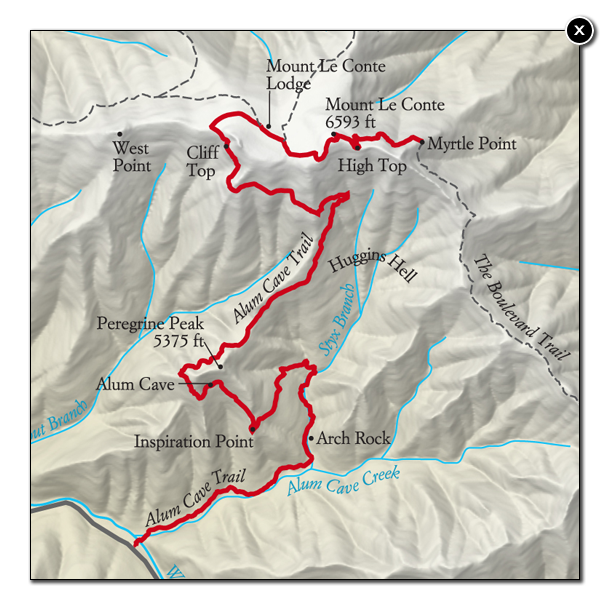
ABOUT THE ROUTE: From the trailhead, follow the well-marked and obvious trail from the parking lot through low-lying woodlands. The trail follows Alum Cave Creek until it ascends toward Arch Rock. Climb the stairs that pass through the rock and get ready for steeper inclines the rest of the way. About a mile past that you’ll reach Alum Cave Bluff. The approach to the bluff is one of the steepest parts of the route, and under the bluff that path is very sandy. From here, it’s 2.7 miles to LeConte’s summit.
The trail continues at a steady uphill grade for another 2 miles. Parts of the trail will be on solid rock, which is often wet, so watch your footing. During late fall and into winter, some of those surfaces will be icy. The park service has installed cables to steady yourself through most of those rocky areas. In addition, the trail often hugs cliffsides, but the exposure on these sections is easily avoided and the risk of falls is minimal.
As you near the LeConte Lodge cabins, the trail levels out. It steepens slightly again past the cabins toward the top. A 6-foot high cairn marks LeConte’s summit. The trail is Class 1 and easy to follow, so the risk of getting off-route is low. The route is 11 miles round-trip; park officials recommend giving yourself 7 hours to complete the hike (including breaks, we did it in about 6.5 hours).
The Smokies are home to a wide variety of wildlife, and black bears are common in the area. Most wildlife will avoid contact with humans, but be sure to properly stow your food and do not approach or try to feed any wildlife, especially bears.

I gladly chose to #OptOutside. (Jen Baines photo)
EXTRA CREDIT: If you have the time, explore the many other trails on LeConte, including the Boulevard Trail (16 miles, 1,080-foot gain), the Bullhead Trail (14.4 miles, 3,820-foot gain), the Rainbow Falls Trail (13 miles, 3,820-foot gain) and the Trillium Gap Trail (13 miles 3,820-foot gain). Closer to the Alum Cave Bluff Trail take the short detour from the lodge to the Cliff Tops, which are famous for their sunset views.
GETTING THERE: From Interstate 40, take Tennessee Highway 66 south (near Kodak). The road will merge with U.S. 441 as you continue south through Sevierville, Pigeon Forge and Gatlinburg. Continuing past Gatlinburg, the Great Smoky Mountains National Park visitor center will appear to your right. The Alum Cave Bluffs trailhead will be 8.6 miles down the road from the visitor center. There is a paved parking lot, but it fills up fast, so don’t be surprised if you have to park on the side of the road. As a side note, give yourself plenty of time to get through Sevierville, Pigeon Forge and Gatlinburg, especially on weekends and holidays. The towns are often choked with tourist traffic.
Bob Doucette

Beautiful!
It is. And worth seeing.
If I ever get up that way I will definitely go. I love the outdoors! Thank you for sharing.
No prob! And thanks for reading. If you go, I think you’ll like it.
Pingback: The year that was: Looking back on a challenging, educational and fruitful 2015 | proactiveoutside
Pingback: Hiking in Great Smoky Mountains National Park, Tennessee – proactiveoutside
Pingback: Oklahoma outdoors: Hiking in the Wichita Mountains, climbing Mount Mitchell – proactiveoutside
Pingback: Arkansas hiking: Hawksbill Crag via Whitaker Point Trail – proactiveoutside
Pingback: Arkansas hiking: Hawksbill Crag via Whitaker Point Trail — proactiveoutside – Best of the Midwest – Hiking, nature and photography