
David at the top of Broken Hand Pass, contemplating the storm and the descent.
The term “adventure” means different things to different people. For some, it could be something as benign as checking out a farmer’s market in a town where you’ve never been. For others, a day of climbing on a new crag or backpacking to a place in which you’re unfamiliar. And for the rare souls, maybe traversing foreign lands solo on a motorcycle, where the language is not your own, the food is strange and the risk of harm from wildlife, weather or other humans is real.
Perspective is everything here. But in my conversations with people about adventure, there is a common thread that surfaces just about every time: Adventure often exists in realms where the unplanned happens. If the success of your plans for a trip or an outing is guaranteed, it’s not an adventure.
This is something I keep in mind every time I head to the mountains. The interaction of elevation, weather and will can make or break your goals in the high country.
I found that out on Longs Peak last summer, when poor weather turned me and my friends back a mile and a thousand feet short of the summit. All that effort, only to walk away with disappointment. That was in the back of my mind when my friend David and I headed into the Sangre de Cristo Mountains to tackle Crestone Peak and Humboldt Peak.
I felt confident that I could handle the challenges of these mountains. But I also know that all mountains – from the benign walk-ups to their burlier, steeper cousins – have the potential to humble the most seasoned among us.
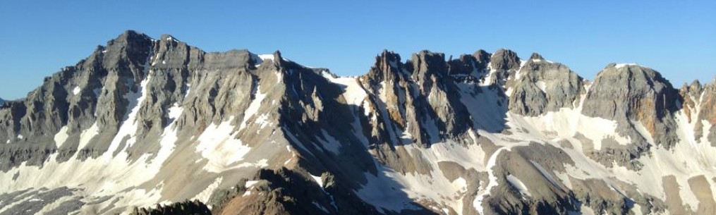
THE PEAKS
The plan was to attempt a climb of Crestone Peak, a rugged spire that shares the skyline with its more elegant kin, Crestone Needle, above South Colony Lakes. We’d considered climbing the Needle, but neither of us had been on that mountain before, and we’d read reports of people having route-finding problems in the way down. About a month ago, a climber died from a fall after going down the wrong gully, and just last week, another fall on the Needle required an extraction from a local search and rescue team. Crestone Peak is much more straightforward, so we opted for that mountain instead.
Crestone Peak is no piece of cake. The bulk of the ascent involves a good amount of exposed, sustained climbing on good, knobby rock. That has a special appeal, but the quality of the rock does not mean this is an easy mountain to climb. It has its challenges, too, and if you’re caught high on the peak with weather moving in, it’s a dangerous place to be. It’s considered the ninth-most-difficult of the 58 14,000-foot peaks in Colorado for a reason.
Humboldt Peak has a completely different nature than the Crestones. It’s a straightforward hike up it’s cool, windswept west ridge, and its appearance – described by mountaineer and author Gerry Roach as “a shapeless hump” – makes it seem like far less of a challenge than its South Colony Lakes neighbors. Objectively speaking, this is true. But even Humboldt has its surprises, particularly when snow and ice is present. Cliff bands on the middle and lower flanks of its slopes have proven to be quite dangerous to the unwary who have attempted glissades and ski descents. Humboldt has been known to kill. Snow and ice were nearly absent in the area when we arrived, but stories of mishaps on all these peaks were good reminders not to take any of them lightly.
ALTITUDE, RAIN AND CHILLED TO THE BONE
When I go to the mountains, one of my biggest obstacles is altitude. I live far away, at 800 feet above sea level. Even when I’m in shape, the challenge of altitude is high. No amount of running, hill climbs or heat training has adequately prepared me for hiking uphill with a loaded pack at 10,000 feet or higher.
So backpacking into South Colony Lakes was laborious. A road that led higher up the route had since been closed, so it’s a few miles from the new four-wheel-drive trailhead to the campsites near the lakes. It’s not steep, but it feels that way when your lungs and heart are still operating as if they were at sea level. Past the old upper trailhead, the route gets a little steeper and more rugged.
Rain began to intermittently fall on us as we hiked higher. Temperatures dropped. The level of work my body was putting in had already made me sweat through my shirt, so a little rain wasn’t going to make any difference. But things changed once we got to our campsite and stopped hiking. With the activity that kept my core temperature up now over, the whole “cold and wet” thing took over.
“Man, I need to get myself going,” I told David as I tried to get the tent out of my pack and get it set up, shivering.
“Yeah, can barely get my fingers to work right,” he said.
We fumbled around with the tent poles and the stakes until we finally got our shelter in place. There was still some campsite work to be done, but as my shivering grew more extreme, I decided I needed to get in my sleeping bag immediately. I had to warm up.
So I crawled into my bag and shook for about 40 minutes as the sun continued to set. I felt a little bad about it, partially because of the aforementioned camp chores that still awaited, but also because I felt like the weak link. Something that’s always in the back of my mind is a hope that my own deficiencies do not hinder my friends from achieving their goals. David has more than 60 summits under his belt, and from past experiences (we’ve climbed Mount Sneffels and Wetterhorn Peak together) I knew that he was the senior partner on this venture. I wondered if the sight of me huffing and puffing up to camp, and now shivering in my sleeping bag was bringing him down. It certainly didn’t look like a good omen to me.
After a bit, I rallied enough to get out of the tent and help out a little before we called it a night. Neither of us slept much, but consolation came as the clouds cleared and the stars came out. One of the benefits of having to take a leak in the middle of the night is getting a quiet moment to look at the night sky, and the tens of thousands of stars that shine overhead in ways you cannot appreciate inside a city or at lower altitudes.
I tucked in again and listened to high winds build through the pre-dawn hours. Sleep never came as I wondered what those winds would be like going over Broken Hand Pass, and then higher on the peak. Thankfully, the winds subsided by dawn, but the pass had its own obstacles.
A THOUSAND FEET OF YUCK

Alpenglow on Crestone Needle.
By morning, I was surprisingly energetic. Maybe it was the fact that the winds died down, or that bright sunshine seemed to indicate favorable conditions for the day. Our first sight was alpenglow hitting Crestone Needle – one of the most beautiful alpine scenes you could ever ask for. The Needle is a lot of things, but first and foremost, it’s one of the most striking peaks I’ve ever seen.
The hike toward the pass is pleasant enough. But the pass is anything but. Broken Hand Pass is just shy of 1,000 feet above South Colony Lakes and is gained by hiking and scrambling up a loose, rubble-filled mess of a gully before ending with a short, grassy slope near the top.
We burned a lot of energy going up this pass, and David wondered aloud what it would be like descending it on our way back.

Looking up toward Broken Hand Pass.
The pass wasn’t a total bust – it had a short section of scrambling that was sort of fun, and a taste of what we hoped to see later when we reached the peak. But our progress was slow, and rockfall a concern. We both agreed that the gully and the pass would not be a good place to be if the weather turned.
Topping out at just shy of 13,000 feet, we looked down into mellower slopes leading toward Cottonwood Lake, and later, to the base of Crestone Peak.
Low clouds were beginning to blow in from the west, but it was still mostly sunny and the temps began to warm. Sunshine seemed to bring life into the valley, and by that, I mean the bugs. Once things warmed, mosquitoes and flies rose from the marshes and set upon us almost immediately. It was great motivation to get moving, get higher and get away from the swarm that sought to feast on us that morning.

At the top of Broken Hand Pass, looking down at Cottonwood Lake.
ON THE PEAK
For awhile, it appeared the clouds coming from the west were only going to amount to fog. They’d obscured Crestone Peak for much of the morning, but cleared just long enough for us to get a good look at the route. Some steeper hiking led to a signature feature in the middle of the mountain, the Red Gully, a water-worn strip of red rock that splits the center of the mountain’s south face. Above it were rockier, steeper pitches of conglomerate rock that were said to make for enjoyable, sustained climbing all the way to the peak’s summit.

Going up the Red Gully on Crestone Peak.
It’s important to note that the type of rock in the Red Gully is different than what is higher up. Runoff from the mountain flows down the face and has worn much of the gully smooth. It’s not that steep, but it is slick in spots, even more so when wet. You need good traction from your footwear at this point, something David was having trouble finding.
His boots were only a year old, but the tread, for whatever reason, wasn’t allowing him to smear the face of the gully without slipping. As the gully steepened, the problems only got worse.
“I think I’m getting past my comfort zone here,” he said, while also saying he wished he had has trail runners on at that point. “I can’t get any grip.”
We stopped for a few minutes to assess the situation. We figured getting up the gully could be managed, but getting down could get difficult. Water continued to flow down the gully’s center, reminding us what had made the rock so slick, and foretelling what it might be like should we get caught in rain. I looked up and saw the route ahead, with still another 1,000 feet or more of climbing yet to do. Crestone’s summit was again hidden by clouds, and over a couple of ridges, those clouds appeared to build. The forecast for the day predicted a chance of storms early that afternoon, but it was clear that those storms were arriving early. With well over an hour of climbing ahead of us just to summit and the other problems now at hand it wasn’t looking good. Halfway up the Red Gully, we pulled the plug.

Gathering clouds around the ridge between Crestone Peak and Crestone Needle.
David was feeling pretty bad about it, noting that I’d come a long way to do this particular peak. But if there is one thing I appreciate about him is his respect for risk, and his experience in determining what those risks are. I’m positive we could have summitted. I’m not so sure how safe the downclimb would have been, especially considering how the skies were beginning to look. As they day wore on, his boot problems might have been providential, giving us pause at the correct moment to turn around before we became overcommitted going up as the weather worsened.
RETREAT OVER THE PASS

Wildflowers galore.
While it was a bummer to bail on the summit, it did allow for more time to enjoy the scenery around Cottonwood Lake. The monsoons had given the lake plenty of water, fed by runoff from the surrounding peaks and a busy little stream that split the valley. By early August, many of the wildflower blooms were long over, but not here. The banks of the stream were carpeted by tall plants with golden blooms, a great contrast to the green grasses and stony brown and gray walls surrounding the lake. Above us, clouds continued to move in like freight trains, quickly and steadily rushing across the skies and in between the spires high above. The interplay between the sun and the clouds, of bright light and dark shadows, gave the entire valley an ethereal feel. I stopped frequently to look up and around, taking pictures and enjoying the wild scenery before the real work of reascending Broken Hand Pass began.
Both of us had talked about the possibility of hiking Humboldt Peak the next morning. It’s a less demanding ascent, but we were pretty beat. But after getting turned back on Crestone Peak, there was more determination to salvage what we could out of the trip.
That thought had us looking ahead, perhaps a bit too far. The skies reminded us to pay attention to the now.

Ominous optics at Cottonwood Lake.
About two-thirds of the way up the pass, a loud and prolonged peal of thunder sounded off. The best I could tell, it came from the east, and the weather patterns indicated that anything going east of us would be heading away. Even then, I knew lightning strikes could travel in any direction. But no matter what, we’d be forced to keep climbing. It didn’t matter what the storm was doing – we still had to go up and over the pass in order to get into camp and relative safety. There was no good place to shelter where we were, or back down at Cottonwood Lake. We’d have to take our chances high on the pass and in the trickier parts of the descent on the other side and hope for the best.
Near the top of the pass, another peal of thunder, this time louder, bouncing off the walls of the mountains in a fast-moving explosion of echoes, like timed dynamite charges. The clouds darkened. Again, it was east of us. But it was a sign to get moving and get down quickly.
When we topped out, we could see the storm and its handiwork. Large volumes of rain were falling, and traces of hail or grauppel – we weren’t sure which – frosted the rugged cliff bands of Humboldt Peak. It was quite a sight, dark and forbidding. But it also confirmed to us that the storm was moving on and had not dumped much of anything on the pass. A good sign, seeing that the descent would be tricky enough as it was.
It took awhile to get down. We descended in choreographed segments, making sure whoever was downslope was clear of the fall line in case the person above accidentally kicked something loose. Rockfall is a real issue on the east side of Broken Hand Pass.
As time passed, the weather improved. We were tired and cursed the difficulties of the pass (“If I never see Broken Hand Pass again, it will be too soon,” I muttered more than once), but optimistic about what we could do the next day.
ONE MORE SURPRISE
The steepness of the trail eased once we reached the lakes. The day was ending well, and the upside to the hike was clearly seeing the route on Humboldt. David said the trail work done there recently was excellent, and its length wasn’t that much, so a good night’s sleep and some hot food should have had us ready to roll the next morning.

David near the bottom of Broken Hand Pass.
We entered the woods just below the lakes and neared camp. About then David stopped and walked up to a partially uprooted tree, then pointed it out to me.
Looking around a bit, he said, “It’s gone.”
By “it,” he meant his bear canister. He’d stashed it there, about a hundred feet away from our tent, as per the instructions that came with it. All of our food was in that canister, with the exception of what we had in our summit packs: half a summer sausage, a couple of cheese sticks, some apple sauce, trail mix and some dried fruit. Barely enough for one person’s single meal.
We looked around camp. No sign of it. One of two things happened: There is currently a bear around South Colony Lakes playing soccer with David’s canister, or someone saw where it was stashed and made off with it.
I’m thinking it was people rather than wildlife. There had been no reports of bear activity in the area that we’d heard of, and no signs of bear tracks or scat. A brand new canister loaded with food might have been tempting to campers lacking a conscience.
What this meant for us: Humboldt was now a no-go. That choice had been made for us by others. The only question remaining was whether we stayed the night and hiked out in the morning or packed out that afternoon.
We chose the latter. But not before chowing down on what we had left and getting a good snooze. We earned that much. Once that was done and we started packing out, David said something that summed up the last two days:
“Well, you could definitely say we had an adventure.”
I thought about that for a bit, and it stuck with me. Yes, we did have an adventure. It wasn’t a Mallory-on-Everest adventure, or Amundsen-Scott in Antarctica, but it was an adventure. We had some hardships, like the beginnings of hypothermia. There were challenges, like getting over Broken Hand Pass. Threats from the skies, like high winds in the middle of the night and storms the next day. And in some cases, too much of the wrong things to make the trip “a success,” when weather, gear and human morality all failed.
But it wasn’t a total loss. In between all those misfortunes were grand scenes of some of the most dramatic places in the Colorado high country: the rays of the rising sun bathing Crestone Needle, for example. The lush greenery around Cottonwood Lake. The fierce ramparts of Crestone Peak, shrouded in clouds, glowering at us from a couple of thousand feet above. Those sights are seared into my memory, as is the knowledge gained from being there. If there’s a next time, I have a good idea what to expect.
I also had good company. That matters when you’re out in the backcountry. A good, strong partner who can hold a conversation is valuable, especially when it’s someone you know you can trust and who will put up with your own flaws.
So we did have an adventure, one that didn’t go as planned. But it was worthwhile nonetheless.

Hiking out.
Bob Doucette

Great read– glad to hear that everyone got down safe!
For sure! That’s the key thing, finding responsible partners who know when to say when.
Climbing can’t be win or lose – Alex Lowe was right about that. Solid decisions.
I hope it was a bear. Taking somebody else’s food in the backcountry, even the Colorado ‘backcountry’, is about as low as it gets.
Agreed on all counts. The food problem could have been way worse, I suppose.
Pingback: South Colony Lakes, Humboldt Peak and a bunch of Colorado 13ers – proactiveoutside